
Seattle history from the water
The People of Portage Bay Before the Denny Party
Long before Seattle became a city of bridges, houseboats, highways, and waterfront parks, the inland waterways around Portage Bay, Lake Union, Union Bay, and Lake Washington were home to Native people who knew these shorelines as travel corridors, fishing grounds, village sites, wetlands, prairies, and places of ceremony.

Before Seattle Was Seattle
It can be hard to imagine that, not long ago in the full sweep of human history, Native people were the only people living in and around the land and water we now know as Seattle. Evidence of human habitation around Puget Sound reaches back thousands of years, meaning Euro-American settlement represents only a small fraction of the human story of this place.
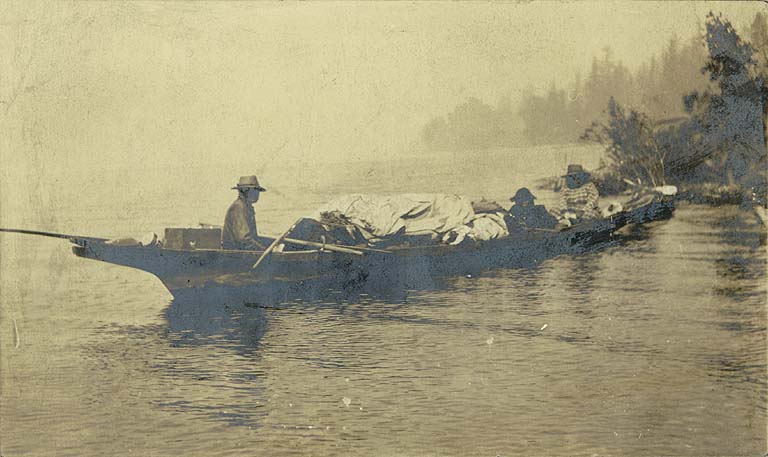
For generations, Lushootseed-speaking people knew these lakes, bays, streams, portages, prairies, and wetlands intimately. They traveled by canoe, harvested salmon and waterfowl, gathered roots and medicinal plants, burned prairies to renew useful foods, and maintained social and spiritual relationships with the land and water.
The arrival of explorers, traders, settlers, and the Denny Party in the 19th century changed this world profoundly. Disease, land seizure, forced displacement, and aggressive settlement transformed Native life around Seattle. Yet Indigenous presence, history, and cultural memory remain deeply embedded in the names, shorelines, stories, and waterways around Portage Bay and Lake Union.
Portage Bay: WaQwaQab and the Canoe Carry
A paddle tour around Seattle’s inland waterways is one of the best ways to begin understanding Native inhabitation around Portage Bay, Lake Union, Lake Washington, and Union Bay. These places were not empty spaces waiting for a city. They were named, known, used, and cared for.
The waterway now called Portage Bay was associated with the Lushootseed name Skhwacugwit, often translated as “Canoe Carry.” Lake Washington was known as Hah-choo, or “Large Lake,” while Lake Union was known as Ha-ah-chu, or “Littlest Lake.”
The launch area near Agua Verde’s docks was once close to a small creek draining the hillside now occupied by the University of Washington. This place was known by the Lushootseed name WaQwaQab, translated as “Doing Like a Frog” or “Croaking.” Whether the name referred to frogs themselves or to the sound of gurgling creek water, it points to a quieter, wetter shoreline than the busy boating corridor we know today.
This part of Portage Bay was also significant because it marked the western end of an ancient Native footpath linking Portage Bay to Lake Washington. The modern Burke-Gilman Trail follows part of this historic corridor. Before the Montlake Cut existed, canoes had to be carried overland between the lake systems.
Lake Union Before Houseboats, Shipyards & Seaplanes
Paddle west from Portage Bay toward Lake Union and you move through a landscape layered with Native place names beneath today’s bridges, boatyards, floating homes, marinas, and parks.
Near the east end of Lake Union was a prairie known as Bahquahb, where Native women cultivated herbs, roots, and other useful plants. Occasional prescribed burns helped renew the soil and stimulate the growth of important foods. Historians believe digging and burning rights here were connected to women from nearby Native villages including Shulshool, associated with Salmon Bay, and Shloowheel, translated as “Little Canoe Channel.”
Continue along the north shore and Gas Works Park soon appears. The Native name for that protruding point was Stacheech, translated as “extended from the ridge.” In Native lore, it was described as a “prop holding up a house,” an image that fits the way the point supports the slope of Wallingford above Lake Union.
Farther west toward the Fremont Canal, today’s industrial shoreline overlays older fishing places. A former salmon stream once ran up into what is now Fremont, and Native fishers used the stream mouth as a productive harvest site. Nearby Gwaxwap, meaning “outlet” or “leak at bottom end,” marked another important fishing area near the western outlet of Lake Union.
From Tlupeelweehl to South Lake Union
Continuing south along the western shore of Lake Union, paddlers now pass some of Seattle’s grandest floating homes and houseboats, including the well-known Sleepless in Seattle floating home. But before the shoreline became famous for high-value waterfront living, Native people knew this deep-water stretch as Tlupeelweehl, or “deep for canoes.”
Near today’s Lake Union Park was Schakwshud, translated as “foot end of the trail to the beach.” This area connected by trail toward what later became Yesler’s sawmill and to productive prairie land farther south.
On the east side of Lake Union, near today’s Terry Pettus Park and the foot of Newton Street, Native people knew the shoreline as SaxWababatS, or “jumping over driftwood,” a name that evokes a lakeshore once thick with logs, woody debris, and natural shoreline complexity.

Cheshiahud and Tleebuleetsa on Portage Bay
After exploring Lake Union, paddlers can return beneath the I-5 and University bridges and follow the north side of Portage Bay. Today, this shoreline is lined with floating homes and houseboats. About 150 years ago, it was a marshy lakeshore where Native people hunted waterfowl and lived close to the wetland edge.
Cheshiahud, also known as “Lake Union John,” lived above the marsh with his wife Tleebuleetsa. He made a living crafting traditional canoes and serving as a canoe guide for non-Native settlers, including his friend David Denny, one of the original members of the Denny Party that landed at Alki in 1851.
Cheshiahud and Tleebuleetsa became well known in early Seattle and were often described as the “Last of the Lake Union Indians,” because they were among the last Native people to maintain a residence along the lakeshore as the city grew around them. Their land near the foot of modern-day Shelby Street had been given to them by David Denny.
After Tleebuleetsa’s death, Cheshiahud sold the land and moved to the Suquamish Reservation at Port Madison, across Puget Sound, where his daughter and other relatives lived.
The Montlake Cut and the Old Portage
For more Native history, paddlers can set a course for the Montlake Cut. Today, paddling from Portage Bay to Lake Washington is direct, but before construction of the man-made cut in the early 20th century, canoes had to be carried across the isthmus.
Native people called this land crossing s-hwah-tsahd-weethl, often translated as “Carry-a-Canoe.” The name preserves the memory of a travel route that predates the canal, the bridges, the ship canal system, and the modern cityscape.
Paddling through the Montlake Cut can be exciting, but it is not always easy. Wind, current, boat traffic, wakes, and narrow-channel conditions can make this stretch challenging. Stay alert, keep moving, and give powered vessels plenty of room.
Union Bay, Ravenna Creek & Foster Island
After passing through the Montlake Cut, head north along the University of Washington shoreline. You’ll pass Husky Stadium, the UW waterfront, and the crew team’s shell house before the scene softens into reeds, wetlands, waterfowl, and native plants around Union Bay.

Before the Montlake Cut lowered and reshaped nearby waterways, what is now the Union Bay Natural Area was part of a larger shallow, boggy bay fed by Ravenna Creek from the north. Near the present site of University Village was S-thloo-weethl, translated as “Little Canoe Channel,” an important Native village with cedar-plank longhouses and a fishing weir at the mouth of Ravenna Creek.
Local Native people harvested salmon here as the fish returned upstream, and they hunted ducks and other waterfowl in the surrounding marshes with spears and nets. The wetland was not an empty or marginal place. It was a productive, carefully known landscape.
Looking south, paddlers can see Foster Island, now part of Seattle’s park system and connected to the Arboretum by trails and footbridges. For millennia, Foster Island was a sacred tribal burial ground known as Stitici. Tribal leaders reminded planners of this ancient use during the expansion planning for State Route 520, which crosses directly over the island.
A Native History Paddle from Agua Verde
Many of these sites are within a reasonable paddle of Agua Verde’s docks. Taken together, they create a route through the layered history of Seattle’s inland waterways: Portage Bay, Lake Union, the Montlake Cut, Union Bay, and the shorelines that Native people named, traveled, harvested, and inhabited long before the Denny Party arrived.
Possible route highlights
- Launch from Agua Verde near the former creek site associated with WaQwaQab.
- Scan Portage Bay and remember the old canoe-carry route toward Lake Washington.
- Paddle west into Lake Union past the north shore, Gas Works Park, and old fishing places.
- Circle South Lake Union while considering the older place names beneath today’s cityscape.
- Return along north Portage Bay near the former home of Cheshiahud and Tleebuleetsa.
- Optional extension: continue through the Montlake Cut to Union Bay when conditions are safe.
Learning about Native uses of the land and water reveals a different Seattle: one where salmon streams, canoe routes, wetlands, prairies, and seasonal harvest sites formed a living network. It also offers a lesson for the future. A lighter touch on the shoreline can help keep salmon running, native plants growing, birds returning, and urban ecosystems more resilient.
Explore Seattle’s Waterways by Kayak
Launch from Agua Verde Paddle Club on Portage Bay and experience Seattle’s inland waterways from a different perspective — one shaped by Native history, shoreline ecology, working waterfronts, floating homes, bridges, and wildlife.
Further Reading
Portage Bay Native History FAQ
What Native people lived around Portage Bay and Lake Union?
The waterways around Portage Bay, Lake Union, Lake Washington, and Union Bay were home to Lushootseed-speaking Native people, including Duwamish people and other related Coast Salish communities whose histories remain connected to these places.
What did Native people call Portage Bay?
Portage Bay was associated with the Lushootseed name Skhwacugwit, often translated as “Canoe Carry.” The name reflects the old portage route between Portage Bay and Lake Washington before the Montlake Cut existed.
Who were Cheshiahud and Tleebuleetsa?
Cheshiahud, also known as “Lake Union John,” and his wife Tleebuleetsa lived near Portage Bay as Seattle grew around them. Cheshiahud was known as a canoe maker and guide and became one of the most remembered Native figures associated with Lake Union.
Can you see these Native history sites by kayak?
Yes. Many of the places discussed in this article are visible or approachable from the water by kayak, including Portage Bay, Lake Union, the Montlake Cut, Union Bay, and the shorelines near the University of Washington.
Is the Montlake Cut safe to paddle?
The Montlake Cut can be paddled when conditions are appropriate, but it is a narrow working waterway with boat traffic, wind, current, and wakes. Paddlers should choose the route only when it matches their ability and the day’s conditions.
What is the best way to learn more about Native Seattle?
Start with tribal sources, local Native history projects, Coll Thrush’s Native Seattle, the Waterlines Project, and place-name resources that document Lushootseed names and Indigenous histories around Seattle’s waterways.